 vesseltracker.com
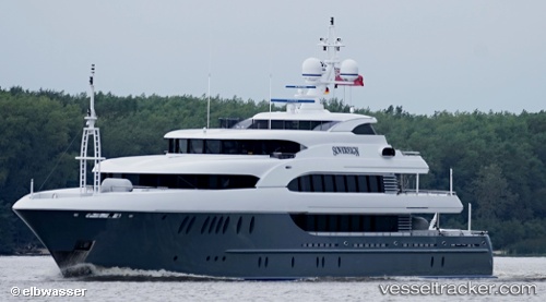
 Sovereign
Current Status
Where is the vessel?
Sovereign is currently in 32 nm SW of Cape Eleuthera, based on AIS data received less than 1h ago.
Latest AIS update:
Current position: 24.46617° N, 76.78073° W (32 nm SW of Cape Eleuthera)
Average speed (last 7 days): Loading…
Average speed (last 30 days): Loading…
Vessel profile: Sovereign is a Service Ship with dimensions 55m x 10m.
This page combines live AIS, route history, probable destination signals, nearby traffic, and port activity for practical vessel monitoring.
The current position of vessel Sovereign is 24.46617 lat / -76.78073 lng. Updated: 2026-05-15 17:53:54 UTCNearest reference points:
- 30 nm SW of Cape Eleuthera
- 29 nm SW of Cape Eleuthera
- Near Nassau
Currently sailing under the flag of Cayman Is ![]()
Sovereign built in 2011 year
Deadweight:
189 tDetails:
Live Vessel Sovereign Analytics (details, animations, etc.)
Recent AIS points (UTC):
2026-05-15 13:44:55 UTC · 24.46652, -76.78065 · SOG 0 kn · COG 261°2026-05-15 16:05:56 UTC · 24.46623, -76.78067 · SOG 0 kn · COG 267°
2026-05-15 16:17:58 UTC · 24.46626, -76.78061 · SOG 0.1 kn · COG 268°
2026-05-15 17:53:54 UTC · 24.46617, -76.78073 · SOG 0 kn · COG 285°