 vesseltracker.com
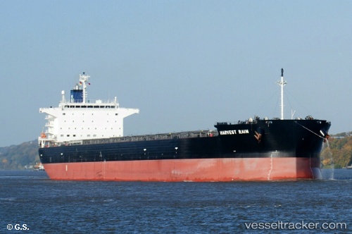
 Harvest Rain
Current Status
Where is the vessel?
Harvest Rain is currently in Near HOEK VAN HOLLAND, based on AIS data received about 7d ago.
Latest AIS update:
Current position: 51.96108° N, 4.12514° E (Near HOEK VAN HOLLAND)
Average speed (last 7 days): Loading…
Average speed (last 30 days): Loading…
Vessel profile: Harvest Rain is a Bulk Carrier with dimensions 237m x 40m.
This page combines live AIS, route history, probable destination signals, nearby traffic, and port activity for practical vessel monitoring.
The current position of vessel Harvest Rain is 51.96108 lat / 4.12514 lng. Updated: 2026-04-24 04:06:00 UTCNearest reference points:
- Near HOEK VAN HOLLAND
- Near MAASVLAKTE - ROTTERDAM
- Near BRIELLE
Currently sailing under the flag of Marshall Is ![]()
Details:
Live Vessel Harvest Rain Analytics (details, animations, etc.)
Recent AIS points (UTC):
2026-04-24 04:06:00 UTC · 51.96108, 4.12514 · SOG 0.1 kn · COG 151°2026-04-24 04:06:00 UTC · 51.96108, 4.12514 · SOG 0.1 kn · COG 151°
2026-04-24 04:06:00 UTC · 51.96108, 4.12514 · SOG 0.1 kn · COG 151°
2026-04-24 04:06:00 UTC · 51.96108, 4.12514 · SOG 0.1 kn · COG 151°