 vesseltracker.com
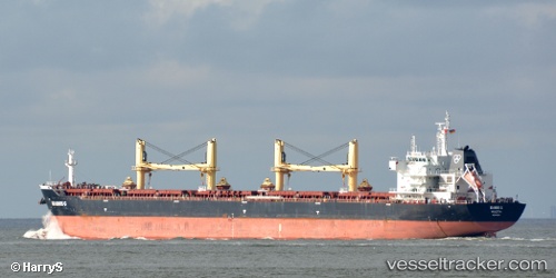
Flag Filia
Current StatusWhere is the vessel?
Flag Filia is currently in 90 nm SW of Jonesville, based on AIS data received about 1h ago.
Latest AIS update:
Current position: 38.49833° N, 54.65833° W (90 nm SW of Jonesville)
Average speed (last 7 days): Loading…
Average speed (last 30 days): Loading…
Vessel profile: Flag Filia is a Bulk Carrier with dimensions 32m x 189m.
This page combines live AIS, route history, probable destination signals, nearby traffic, and port activity for practical vessel monitoring.
The current position of vessel Flag Filia is 38.49833 lat / -54.65833 lng. Updated: 2026-05-15 07:51:41 UTCNearest reference points:
- 153 nm S of Jonesville
- 44 nm SE of Jonesville
- 153 nm NW of Jonesville
Details:
Live Vessel Flag Filia Analytics (details, animations, etc.)
Recent AIS points (UTC):
2026-05-15 04:15:43 UTC · 38.35667, -55.37500 · SOG 9 kn · COG -1°2026-05-15 05:33:42 UTC · 38.42667, -55.10500 · SOG 9 kn · COG -1°
2026-05-15 07:30:42 UTC · 38.48500, -54.73000 · SOG 9 kn · COG -1°
2026-05-15 07:51:41 UTC · 38.49833, -54.65833 · SOG 9 kn · COG -1°