 vesseltracker.com
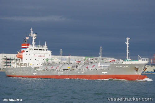
 Buena Alba
Current Status
Where is the vessel?
Buena Alba is currently in 38 nm N of SURALAYA, based on AIS data received less than 1h ago.
Latest AIS update:
Current position: 5.26667° S, 106.22667° E (38 nm N of SURALAYA)
Average speed (last 7 days): Loading…
Average speed (last 30 days): Loading…
Vessel profile: Buena Alba is a Lpg Tanker with dimensions 96m x 16m.
This page combines live AIS, route history, probable destination signals, nearby traffic, and port activity for practical vessel monitoring.
The current position of vessel Buena Alba is -5.26667 lat / 106.22667 lng. Updated: 2026-04-27 12:18:46 UTCNearest reference points:
- 38 nm E of Kotatengah
- Near SURALAYA
- Near MERAK
Currently sailing under the flag of Panama ![]()
Details:
Live Vessel Buena Alba Analytics (details, animations, etc.)
Recent AIS points (UTC):
2026-04-27 07:18:48 UTC · -5.97333, 105.98333 · SOG 0 kn · COG -1°2026-04-27 09:38:11 UTC · -5.82541, 105.99388 · SOG 13.6 kn · COG 35°
2026-04-27 11:05:01 UTC · -5.50400, 106.07465 · SOG 13.9 kn · COG 16°
2026-04-27 12:18:46 UTC · -5.26667, 106.22667 · SOG 13 kn · COG -1°