 vesseltracker.com
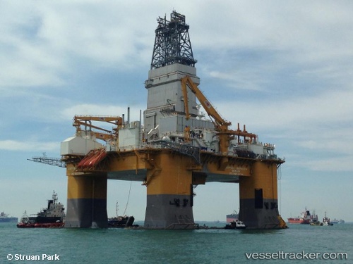
 Deepsea Aberdeen
Current Status
Where is the vessel?
Deepsea Aberdeen is currently in 15 nm S of Fram, based on AIS data received less than 1h ago.
Latest AIS update:
Current position: 60.83765° N, 3.55103° E (15 nm S of Fram)
Average speed (last 7 days): Loading…
Average speed (last 30 days): Loading…
Vessel profile: Deepsea Aberdeen is a Drilling Ship with dimensions 118m x 96m.
This page combines live AIS, route history, probable destination signals, nearby traffic, and port activity for practical vessel monitoring.
The current position of vessel Deepsea Aberdeen is 60.83765 lat / 3.55103 lng. Updated: 2026-05-16 12:22:39 UTCNearest reference points:
- Near Solund
- Near Eivindvik
- Near Glesvær
Currently sailing under the flag of Bermuda ![]()
Details:
Live Vessel Deepsea Aberdeen Analytics (details, animations, etc.)
Recent AIS points (UTC):
2026-05-16 07:44:29 UTC · 60.83766, 3.55104 · SOG 0.2 kn · COG 179°2026-05-16 09:33:10 UTC · 60.83765, 3.55102 · SOG 0.1 kn · COG 179°
2026-05-16 10:03:57 UTC · 60.83765, 3.55102 · SOG 0.1 kn · COG 180°
2026-05-16 12:22:39 UTC · 60.83765, 3.55103 · SOG 0.1 kn · COG 179°