 vesseltracker.com
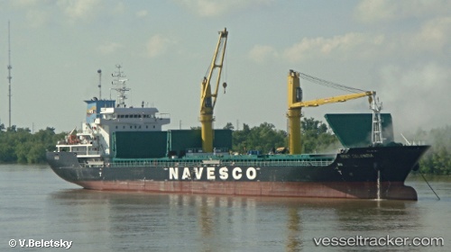
 Sider Colombia
Current Status
Where is the vessel?
Sider Colombia is currently in Near New Orleans, based on AIS data received about 2h ago.
Latest AIS update:
Current position: 29.92167° N, 90.07000° W (Near New Orleans)
Average speed (last 7 days): Loading…
Average speed (last 30 days): Loading…
Vessel profile: Sider Colombia is a General Cargo Ship with dimensions 139m x 22m.
This page combines live AIS, route history, probable destination signals, nearby traffic, and port activity for practical vessel monitoring.
The current position of vessel Sider Colombia is 29.92167 lat / -90.07000 lng. Updated: 2026-05-15 01:22:02 UTCNearest reference points:
- Near Marrero
- Near Meraux
- Near Boutte
Currently sailing under the flag of Panama ![]()
Sider Colombia built in 2012 year
Deadweight:
13166 tDetails:
Live Vessel Sider Colombia Analytics (details, animations, etc.)
Recent AIS points (UTC):
2026-05-14 22:04:01 UTC · 29.92167, -90.07000 · SOG 0 kn · COG -1°2026-05-14 22:09:25 UTC · 29.92225, -90.07140 · SOG 0 kn · COG 243°
2026-05-15 00:19:00 UTC · 29.92167, -90.07000 · SOG 0 kn · COG -1°
2026-05-15 01:22:02 UTC · 29.92167, -90.07000 · SOG 0 kn · COG -1°