 vesseltracker.com
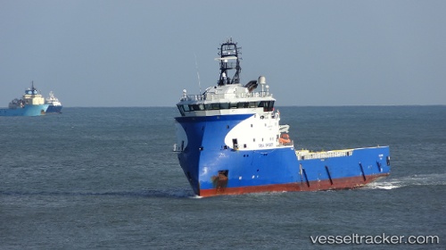
 SERVICE TIDE
Current Status
Where is the vessel?
SERVICE TIDE is currently in 11 nm E of Athena FPSO, based on AIS data received less than 1h ago.
Latest AIS update:
Current position: 58.63167° N, 0.60833° W (11 nm E of Athena FPSO)
Average speed (last 7 days): Loading…
Average speed (last 30 days): Loading…
Vessel profile: SERVICE TIDE is a Offshore Supply Ship with dimensions m x m.
This page combines live AIS, route history, probable destination signals, nearby traffic, and port activity for practical vessel monitoring.
The current position of vessel SERVICE TIDE is 58.63167 lat / -0.60833 lng. Updated: 2026-05-02 18:47:32 UTCNearest reference points:
- Near Peterhead
- Near PETERHEAD
- Near Alba Oil Field
Currently sailing under the flag of United Kingdom ![]()
Details:
Live Vessel SERVICE TIDE Analytics (details, animations, etc.)
Recent AIS points (UTC):
2026-05-02 16:02:30 UTC · 58.89833, -0.35833 · SOG 8 kn · COG -1°2026-05-02 16:02:30 UTC · 58.89833, -0.35833 · SOG 8 kn · COG -1°
2026-05-02 17:38:29 UTC · 58.69833, -0.54833 · SOG 8 kn · COG -1°
2026-05-02 18:47:32 UTC · 58.63167, -0.60833 · SOG 10 kn · COG -1°