 vesseltracker.com
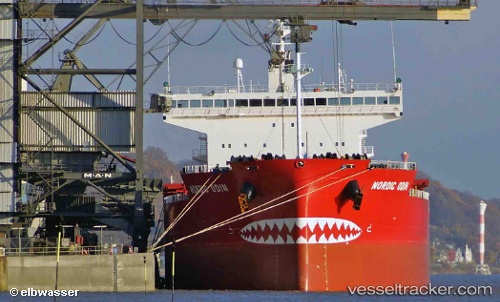
 NORDIC ODIN
Current Status
Where is the vessel?
NORDIC ODIN is currently in Near Port-Cartier, based on AIS data received about 1h ago.
Latest AIS update:
Current position: 50.03209° N, 66.78855° W (Near Port-Cartier)
Average speed (last 7 days): Loading…
Average speed (last 30 days): Loading…
Vessel profile: NORDIC ODIN is a Bulk Carrier with dimensions 225m x 32m.
This page combines live AIS, route history, probable destination signals, nearby traffic, and port activity for practical vessel monitoring.
The current position of vessel NORDIC ODIN is 50.03209 lat / -66.78855 lng. Updated: 2026-05-13 19:51:04 UTCNearest reference points:
- 22 nm N of Sainte-Anne-des-Monts
- 15 nm NW of Saint-Anaclet
Currently sailing under the flag of Marshall Islands ![]()
NORDIC ODIN built in 2015 year
Deadweight:
76180 tDetails:
Live Vessel NORDIC ODIN Analytics (details, animations, etc.)
Recent AIS points (UTC):
2026-05-13 16:58:07 UTC · 50.01361, -66.76027 · SOG 0.1 kn · COG 215°2026-05-13 17:22:04 UTC · 50.01318, -66.76076 · SOG 0.3 kn · COG 218°
2026-05-13 19:33:55 UTC · 50.03211, -66.78854 · SOG 0.1 kn · COG 77°
2026-05-13 19:51:04 UTC · 50.03209, -66.78855 · SOG 0.1 kn · COG 77°