 vesseltracker.com
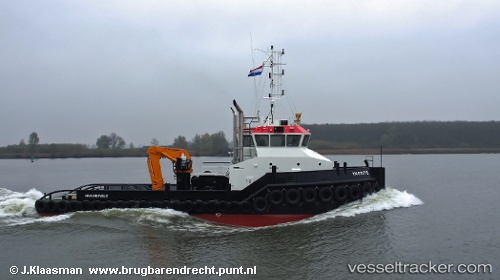
 Wil S
Wil S
Current Status
Where is the vessel?
Wil S is currently in Near EEMSHAVEN, based on AIS data received less than 1h ago.
Latest AIS update:
Current position: 53.44453° N, 6.82737° E (Near EEMSHAVEN)
Average speed (last 7 days): Loading…
Average speed (last 30 days): Loading…
Vessel profile: Wil S is a Tug with dimensions 32m x 9m.
This page combines live AIS, route history, probable destination signals, nearby traffic, and port activity for practical vessel monitoring.
The current position of vessel Wil S is 53.44453 lat / 6.82737 lng. Updated: 2026-05-15 11:43:59 UTCNearest reference points:
- Near Borkum
- Near APPINGEDAM
- Near Kolham
Currently sailing under the flag of Netherlands ![]()
Details:
Live Vessel Wil S Analytics (details, animations, etc.)
Recent AIS points (UTC):
2026-05-15 07:38:07 UTC · 53.44452, 6.82733 · SOG 0 kn · COG 292°2026-05-15 10:01:38 UTC · 53.44450, 6.82735 · SOG 0 kn · COG 292°
2026-05-15 10:16:28 UTC · 53.44452, 6.82736 · SOG 0 kn · COG 291°
2026-05-15 11:43:59 UTC · 53.44453, 6.82737 · SOG 0 kn · COG 293°