 vesseltracker.com
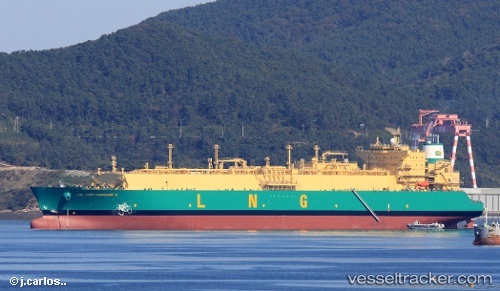
 Lng Port harcourt Ii
Current Status
Where is the vessel?
Lng Port harcourt Ii is currently in 121 nm SE of SAO LUIS, based on AIS data received less than 1h ago.
Latest AIS update:
Current position: 0.97549° S, 1.77098° E (121 nm SE of SAO LUIS)
Average speed (last 7 days): Loading…
Average speed (last 30 days): Loading…
Vessel profile: Lng Port harcourt Ii is a Lng Tanker with dimensions 292m x 292m.
This page combines live AIS, route history, probable destination signals, nearby traffic, and port activity for practical vessel monitoring.
The current position of vessel Lng Port harcourt Ii is -0.97549 lat / 1.77098 lng. Updated: 2026-05-16 05:27:20 UTCNearest reference points:
- 138 nm E of SAO LUIS
- Near SAO LUIS
- Near Porsuk
Currently sailing under the flag of Bermuda ![]()
Details:
Live Vessel Lng Port harcourt Ii Analytics (details, animations, etc.)
Recent AIS points (UTC):
2026-05-16 01:48:40 UTC · -1.87247, 1.70214 · SOG 14.9 kn · COG 7°2026-05-16 03:21:55 UTC · -1.48749, 1.73057 · SOG 14.6 kn · COG 7°
2026-05-16 04:01:40 UTC · -1.32619, 1.74106 · SOG 14.5 kn · COG 7°
2026-05-16 05:27:20 UTC · -0.97549, 1.77098 · SOG 14.7 kn · COG 9°