 vesseltracker.com
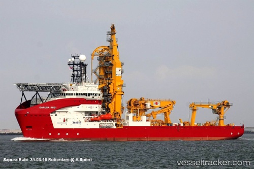
Sapura Rubi
Current StatusWhere is the vessel?
Sapura Rubi is currently in Near Vitoria, based on AIS data received about 1h ago.
Latest AIS update:
Current position: 20.32500° S, 40.34500° W (Near Vitoria)
Average speed (last 7 days): Loading…
Average speed (last 30 days): Loading…
Vessel profile: Sapura Rubi is a Pipe Layer with dimensions 30m x 146m.
This page combines live AIS, route history, probable destination signals, nearby traffic, and port activity for practical vessel monitoring.
The current position of vessel Sapura Rubi is -20.32500 lat / -40.34500 lng. Updated: 2026-04-24 19:57:14 UTCNearest reference points:
- Near Vitoria
- Near BAIA DE VITORIA
- Near JARDIM CAMBURI
Details:
Live Vessel Sapura Rubi Analytics (details, animations, etc.)
Recent AIS points (UTC):
2026-04-24 16:11:58 UTC · -20.32437, -40.34577 · SOG 0 kn · COG 92°2026-04-24 17:59:58 UTC · -20.32438, -40.34575 · SOG 0 kn · COG 92°
2026-04-24 19:48:13 UTC · -20.32500, -40.34500 · SOG 0 kn · COG -1°
2026-04-24 19:57:14 UTC · -20.32500, -40.34500 · SOG 0 kn · COG -1°