 vesseltracker.com
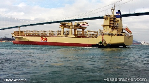
Dole Atlantic
Current StatusWhere is the vessel?
Dole Atlantic is currently in 54 nm SE of El Ranchito, based on AIS data received less than 1h ago.
Latest AIS update:
Current position: 17.88935° N, 103.18945° W (54 nm SE of El Ranchito)
Average speed (last 7 days): Loading…
Average speed (last 30 days): Loading…
Vessel profile: Dole Atlantic is a Container Ship with dimensions 30m x 190m.
This page combines live AIS, route history, probable destination signals, nearby traffic, and port activity for practical vessel monitoring.
The current position of vessel Dole Atlantic is 17.88935 lat / -103.18945 lng. Updated: 2026-05-14 16:10:20 UTCNearest reference points:
- 43 nm SW of Antunez
- 46 nm S of El Ranchito
- Near Lazaro Cardenas
Details:
Live Vessel Dole Atlantic Analytics (details, animations, etc.)
Recent AIS points (UTC):
2026-05-14 13:08:40 UTC · 17.53868, -102.41410 · SOG 16.6 kn · COG 292°2026-05-14 13:25:16 UTC · 17.56912, -102.48788 · SOG 16.7 kn · COG 292°
2026-05-14 16:05:44 UTC · 17.87827, -103.17186 · SOG 15.8 kn · COG 304°
2026-05-14 16:10:20 UTC · 17.88935, -103.18945 · SOG 15.6 kn · COG 303°