 vesseltracker.com
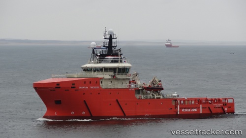
 Grampian Fortress
Current Status
Where is the vessel?
Grampian Fortress is currently in 13 nm N of Liverpool Bay Terminal, based on AIS data received less than 1h ago.
Latest AIS update:
Current position: 53.90046° N, 3.60030° W (13 nm N of Liverpool Bay Terminal)
Average speed (last 7 days): Loading…
Average speed (last 30 days): Loading…
Vessel profile: Grampian Fortress is a Standby Safety Vessel with dimensions 58m x 15m.
This page combines live AIS, route history, probable destination signals, nearby traffic, and port activity for practical vessel monitoring.
The current position of vessel Grampian Fortress is 53.90046 lat / -3.60030 lng. Updated: 2026-05-17 16:09:02 UTCNearest reference points:
- Near LIVERPOOL ANCH
- Near Rhôs-on-Sea
- Near Conwy (Conway)
Currently sailing under the flag of United Kingdom ![]()
Details:
Live Vessel Grampian Fortress Analytics (details, animations, etc.)
Recent AIS points (UTC):
2026-05-17 11:55:40 UTC · 53.90416, -3.58947 · SOG 0.4 kn · COG 230°2026-05-17 14:02:10 UTC · 53.90379, -3.59955 · SOG 0.4 kn · COG 208°
2026-05-17 14:06:50 UTC · 53.90354, -3.59975 · SOG 0.2 kn · COG 212°
2026-05-17 16:09:02 UTC · 53.90046, -3.60030 · SOG 0.4 kn · COG 190°