 vesseltracker.com
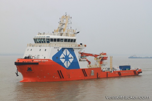
 SAFEEN HYDRA
Current Status
Where is the vessel?
SAFEEN HYDRA is currently in Near Mina Zayed/Abu Dhabi, based on AIS data received less than 1h ago.
Latest AIS update:
Current position: 24.53376° N, 54.36630° E (Near Mina Zayed/Abu Dhabi)
Average speed (last 7 days): Loading…
Average speed (last 30 days): Loading…
Vessel profile: SAFEEN HYDRA is a Other Type with dimensions m x m.
This page combines live AIS, route history, probable destination signals, nearby traffic, and port activity for practical vessel monitoring.
The current position of vessel SAFEEN HYDRA is 24.53376 lat / 54.36630 lng. Updated: 2026-05-13 22:03:04 UTCNearest reference points:
- Near Esnnad
- Near KHALIFA
- 16 nm NW of Jebel Ali
Currently sailing under the flag of Marshall Islands ![]()
Details:
Live Vessel SAFEEN HYDRA Analytics (details, animations, etc.)
Recent AIS points (UTC):
2026-05-13 18:23:42 UTC · 24.53364, 54.36520 · SOG 0.3 kn · COG 352°2026-05-13 19:41:13 UTC · 24.53115, 54.36753 · SOG 2.8 kn · COG 352°
2026-05-13 19:53:09 UTC · 24.53333, 54.36500 · SOG 0 kn · COG -1°
2026-05-13 22:03:04 UTC · 24.53376, 54.36630 · SOG 6.5 kn · COG 352°