 vesseltracker.com
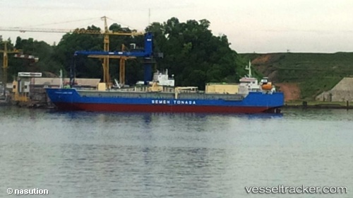
 Tonasa Line Xviii
Current Status
Where is the vessel?
Tonasa Line Xviii is currently in 94 nm SE of Senipah Oil Terminal, based on AIS data received about 4h ago.
Latest AIS update:
Current position: 2.32500° S, 118.12167° E (94 nm SE of Senipah Oil Terminal)
Average speed (last 7 days): Loading…
Average speed (last 30 days): Loading…
Vessel profile: Tonasa Line Xviii is a Cement Carrier with dimensions 112m x 24m.
This page combines live AIS, route history, probable destination signals, nearby traffic, and port activity for practical vessel monitoring.
The current position of vessel Tonasa Line Xviii is -2.32500 lat / 118.12167 lng. Updated: 2026-04-25 14:08:19 UTCNearest reference points:
- 57 nm NE of TANJUNG PEMANCINGAN
- Near Senipah Oil Terminal
- 18 nm E of Senipah Oil Terminal
Currently sailing under the flag of Indonesia ![]()
Details:
Live Vessel Tonasa Line Xviii Analytics (details, animations, etc.)
Recent AIS points (UTC):
2026-04-25 09:15:44 UTC · -1.72761, 117.68333 · SOG 9 kn · COG -1°2026-04-25 14:08:19 UTC · -2.32500, 118.12167 · SOG 9 kn · COG -1°
2026-04-25 14:08:19 UTC · -2.32500, 118.12167 · SOG 9 kn · COG -1°
2026-04-25 14:08:19 UTC · -2.32500, 118.12167 · SOG 9 kn · COG -1°