 vesseltracker.com
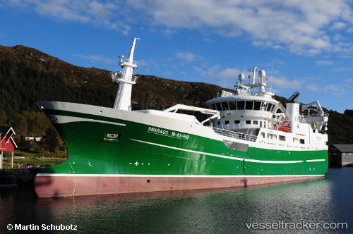
 Smaragd
Current Status
Where is the vessel?
Smaragd is currently in Near Torvika, based on AIS data received less than 1h ago.
Latest AIS update:
Current position: 62.34310° N, 5.69204° E (Near Torvika)
Average speed (last 7 days): Loading…
Average speed (last 30 days): Loading…
Vessel profile: Smaragd is a Fishing Vessel with dimensions 74m x 15m.
This page combines live AIS, route history, probable destination signals, nearby traffic, and port activity for practical vessel monitoring.
The current position of vessel Smaragd is 62.34310 lat / 5.69204 lng. Updated: 2026-05-14 08:26:04 UTCNearest reference points:
- Near Larsnes
- Near Gursken
- Near Alesund
Currently sailing under the flag of Norway ![]()
Details:
Live Vessel Smaragd Analytics (details, animations, etc.)
Recent AIS points (UTC):
2026-05-14 04:32:05 UTC · 62.34310, 5.69201 · SOG 0 kn · COG 33°2026-05-14 05:44:07 UTC · 62.34309, 5.69200 · SOG 0 kn · COG 33°
2026-05-14 07:59:04 UTC · 62.34309, 5.69197 · SOG 0.1 kn · COG 32°
2026-05-14 08:26:04 UTC · 62.34310, 5.69204 · SOG 0 kn · COG 32°