 vesseltracker.com
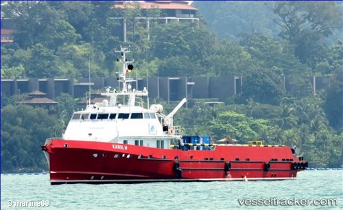
Karol W
Current StatusWhere is the vessel?
Karol W is currently in 23 nm W of Pointe Noire, based on AIS data received about 1h ago.
Latest AIS update:
Current position: 4.78413° S, 11.44054° E (23 nm W of Pointe Noire)
Average speed (last 7 days): Loading…
Average speed (last 30 days): Loading…
Vessel profile: Karol W is a Offshore Tug Supply Ship with dimensions 10m x 54m.
This page combines live AIS, route history, probable destination signals, nearby traffic, and port activity for practical vessel monitoring.
The current position of vessel Karol W is -4.78413 lat / 11.44054 lng. Updated: 2026-05-17 11:42:44 UTCNearest reference points:
- Near Pointe Noire
- Near N'Kossa Terminal
- Near Futila Terminal
Details:
Live Vessel Karol W Analytics (details, animations, etc.)
Recent AIS points (UTC):
2026-05-17 08:15:36 UTC · -4.77981, 11.85093 · SOG 0.1 kn · COG 192°2026-05-17 10:10:05 UTC · -4.76323, 11.64628 · SOG 13.2 kn · COG 296°
2026-05-17 10:51:36 UTC · -4.77883, 11.49817 · SOG 13 kn · COG 262°
2026-05-17 11:42:44 UTC · -4.78413, 11.44054 · SOG 0.6 kn · COG 144°