 vesseltracker.com
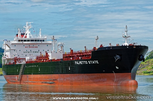
 Palmetto State
Current Status
Where is the vessel?
Palmetto State is currently in Near Wills Point, based on AIS data received less than 1h ago.
Latest AIS update:
Current position: 29.74711° N, 90.01567° W (Near Wills Point)
Average speed (last 7 days): Loading…
Average speed (last 30 days): Loading…
Vessel profile: Palmetto State is a Chemical Oil Products Tanker with dimensions 186m x 32m.
This page combines live AIS, route history, probable destination signals, nearby traffic, and port activity for practical vessel monitoring.
The current position of vessel Palmetto State is 29.74711 lat / -90.01567 lng. Updated: 2026-04-27 17:54:46 UTCNearest reference points:
- Near Marrero
- Near Meraux
- Near Pointe a la Hache
Currently sailing under the flag of USA ![]()
Details:
Live Vessel Palmetto State Analytics (details, animations, etc.)
Recent AIS points (UTC):
2026-04-27 15:47:44 UTC · 29.49748, -89.70318 · SOG 11.7 kn · COG 325°2026-04-27 16:58:18 UTC · 29.62275, -89.90709 · SOG 10.2 kn · COG 307°
2026-04-27 17:30:25 UTC · 29.68709, -89.96775 · SOG 10.1 kn · COG 327°
2026-04-27 17:54:46 UTC · 29.74711, -90.01567 · SOG 11.2 kn · COG 313°