 vesseltracker.com
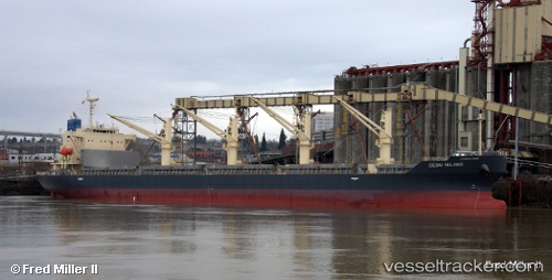
 Cebu Island
Current Status
Where is the vessel?
Cebu Island is currently in Near KIMITSU, based on AIS data received less than 1h ago.
Latest AIS update:
Current position: 35.37193° N, 139.78873° E (Near KIMITSU)
Average speed (last 7 days): Loading…
Average speed (last 30 days): Loading…
Vessel profile: Cebu Island is a General Cargo Ship with dimensions 180m x 180m.
This page combines live AIS, route history, probable destination signals, nearby traffic, and port activity for practical vessel monitoring.
The current position of vessel Cebu Island is 35.37193 lat / 139.78873 lng. Updated: 2026-04-24 07:23:43 UTCNearest reference points:
- Near Yokosuka
- Near Naka-Ku, Kanagawa
- Near Kawasaki
Currently sailing under the flag of Panama ![]()
Details:
Live Vessel Cebu Island Analytics (details, animations, etc.)
Recent AIS points (UTC):
2026-04-24 03:42:21 UTC · 35.37186, 139.78867 · SOG 0 kn · COG 64°2026-04-24 04:35:16 UTC · 35.37167, 139.78833 · SOG 0 kn · COG -1°
2026-04-24 05:44:10 UTC · 35.37167, 139.78833 · SOG 0 kn · COG -1°
2026-04-24 07:23:43 UTC · 35.37193, 139.78873 · SOG 0 kn · COG 64°