 vesseltracker.com
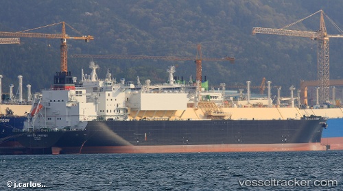
 British Partner
Current Status
Where is the vessel?
British Partner is currently in Near BUKOM ISLAND, based on AIS data received less than 1h ago.
Latest AIS update:
Current position: 1.17184° N, 103.76426° E (Near BUKOM ISLAND)
Average speed (last 7 days): Loading…
Average speed (last 30 days): Loading…
Vessel profile: British Partner is a Lng Tanker with dimensions 295m x 46m.
This page combines live AIS, route history, probable destination signals, nearby traffic, and port activity for practical vessel monitoring.
The current position of vessel British Partner is 1.17184 lat / 103.76426 lng. Updated: 2026-05-15 11:35:00 UTCNearest reference points:
- Near BUKOM ISLAND
- Near JURONG ISLAND
- Near Pasir Panjang Wharves
Currently sailing under the flag of United Kingdom ![]()
Details:
Live Vessel British Partner Analytics (details, animations, etc.)
Recent AIS points (UTC):
2026-05-15 08:22:46 UTC · 1.17469, 103.76906 · SOG 0 kn · COG 247°2026-05-15 10:22:59 UTC · 1.17232, 103.76416 · SOG 0 kn · COG 86°
2026-05-15 11:01:56 UTC · 1.17204, 103.76427 · SOG 0 kn · COG 63°
2026-05-15 11:35:00 UTC · 1.17184, 103.76426 · SOG 0 kn · COG 49°