 vesseltracker.com
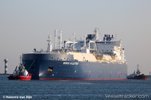
 BORIS VILKITSKY
Current Status
Where is the vessel?
BORIS VILKITSKY is currently in 134 nm NW of Dikson, based on AIS data received less than 1h ago.
Latest AIS update:
Current position: 74.39333° N, 73.04667° E (134 nm NW of Dikson)
Average speed (last 7 days): Loading…
Average speed (last 30 days): Loading…
Vessel profile: BORIS VILKITSKY is a LNG Tanker with dimensions 299m x 50m.
This page combines live AIS, route history, probable destination signals, nearby traffic, and port activity for practical vessel monitoring.
The current position of vessel BORIS VILKITSKY is 74.39333 lat / 73.04667 lng. Updated: 2026-05-16 07:08:20 UTCCurrently sailing under the flag of Cyprus ![]()
BORIS VILKITSKY built in 2017 year
Deadweight:
96958 tDetails:
Live Vessel BORIS VILKITSKY Analytics (details, animations, etc.)
Recent AIS points (UTC):
2026-05-16 03:22:19 UTC · 73.66618, 72.72689 · SOG 5.9 kn · COG 9°2026-05-16 04:07:08 UTC · 73.78255, 72.71303 · SOG 16.2 kn · COG 340°
2026-05-16 06:02:22 UTC · 74.17833, 73.05167 · SOG 9 kn · COG -1°
2026-05-16 07:08:20 UTC · 74.39333, 73.04667 · SOG 7 kn · COG -1°