 vesseltracker.com
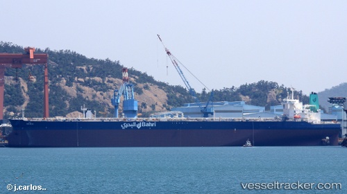
Maharah
Current StatusWhere is the vessel?
Maharah is currently in 361 nm SW of Veraval, based on AIS data received about 1h ago.
Latest AIS update:
Current position: 16.41230° N, 66.11846° E (361 nm SW of Veraval)
Average speed (last 7 days): Loading…
Average speed (last 30 days): Loading…
Vessel profile: Maharah is a Crude Oil Tanker with dimensions 60m x 333m.
This page combines live AIS, route history, probable destination signals, nearby traffic, and port activity for practical vessel monitoring.
The current position of vessel Maharah is 16.41230 lat / 66.11846 lng. Updated: 2026-04-27 17:25:03 UTCNearest reference points:
- Open sea, approx. 401 nm off the nearest listed port
- Open sea, approx. 400 nm off the nearest listed port
- Open sea, approx. 404 nm off the nearest listed port
Details:
Live Vessel Maharah Analytics (details, animations, etc.)
Recent AIS points (UTC):
2026-04-27 13:27:14 UTC · 16.41502, 66.08124 · SOG 0.4 kn · COG 6°2026-04-27 16:20:14 UTC · 16.40936, 66.10927 · SOG 0.4 kn · COG 33°
2026-04-27 16:20:36 UTC · 16.40937, 66.10931 · SOG 0.4 kn · COG 33°
2026-04-27 17:25:03 UTC · 16.41230, 66.11846 · SOG 0.5 kn · COG 20°