 MAERSK CANCUN
Current Status
Where is the vessel?
MAERSK CANCUN is currently in 55 nm SE of Polychnitos Lesvou, based on AIS data received about 14h ago.
Latest AIS update:
Current position: 33.49035° N, 26.99459° E (55 nm SE of Polychnitos Lesvou)
Average speed (last 7 days): Loading…
Average speed (last 30 days): Loading…
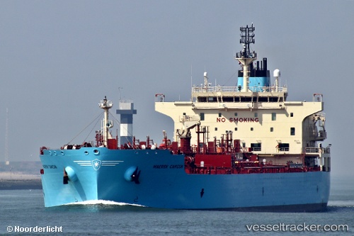
Vessel profile: MAERSK CANCUN is a Chemical/Oil Products Tanker with dimensions 182m x 32m.
This page combines live AIS, route history, probable destination signals, nearby traffic, and port activity for practical vessel monitoring.
The current position of vessel MAERSK CANCUN is 33.49035 lat / 26.99459 lng. Updated: 2026-05-23 22:33:54 UTCNearest reference points:
- 91 nm SE of Polychnitos Lesvou
- 129 nm NW of ABU QIR
- 67 nm S of Kali Limenes
Currently sailing under the flag of Denmark (DIS) ![]()
MAERSK CANCUN built in 2018 year
Deadweight:
49919 tDetails:
Live Vessel MAERSK CANCUN Analytics (details, animations, etc.)
Recent AIS points (UTC):
2026-05-23 19:04:06 UTC · 33.22823, 27.42850 · SOG 8.7 kn · COG 305°2026-05-23 19:04:06 UTC · 33.22823, 27.42850 · SOG 8.7 kn · COG 305°
2026-05-23 19:04:06 UTC · 33.22823, 27.42850 · SOG 8.7 kn · COG 305°
2026-05-23 22:33:54 UTC · 33.49035, 26.99459 · SOG 3.1 kn · COG 304°