 vesseltracker.com
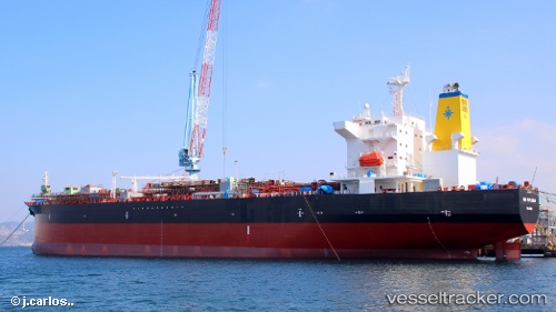
 High Explorer
Current Status
Where is the vessel?
High Explorer is currently in 58 nm N of PUERTO BOLIVAR, based on AIS data received about 1h ago.
Latest AIS update:
Current position: 13.21220° N, 72.12280° W (58 nm N of PUERTO BOLIVAR)
Average speed (last 7 days): Loading…
Average speed (last 30 days): Loading…
Vessel profile: High Explorer is a Chemical Oil Products Tanker with dimensions 182m x 182m.
This page combines live AIS, route history, probable destination signals, nearby traffic, and port activity for practical vessel monitoring.
The current position of vessel High Explorer is 13.21220 lat / -72.12280 lng. Updated: 2026-04-27 11:35:58 UTCNearest reference points:
- Near PUERTO BOLIVAR
- 24 nm NW of Palm Beach
- Near Las Piedras
Currently sailing under the flag of Luxembourg ![]()
High Explorer built in 0 year
Deadweight:
0 tDetails:
Live Vessel High Explorer Analytics (details, animations, etc.)
Recent AIS points (UTC):
2026-04-27 07:47:46 UTC · 12.87010, -72.85399 · SOG 12 kn · COG 71°2026-04-27 09:47:17 UTC · 13.05224, -72.48397 · SOG 12.3 kn · COG 64°
2026-04-27 10:51:05 UTC · 13.14282, -72.27429 · SOG 12.7 kn · COG 64°
2026-04-27 11:35:58 UTC · 13.21220, -72.12280 · SOG 13 kn · COG 64°