 vesseltracker.com
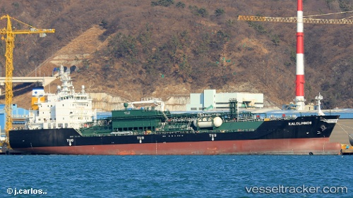
 KALOLIMNOS
Current Status
Where is the vessel?
KALOLIMNOS is currently in 29 nm SW of Kukdo, based on AIS data received about 1h ago.
Latest AIS update:
Current position: 34.11155° N, 128.13567° E (29 nm SW of Kukdo)
Average speed (last 7 days): Loading…
Average speed (last 30 days): Loading…
Vessel profile: KALOLIMNOS is a LPG Tanker with dimensions 147m x 23m.
This page combines live AIS, route history, probable destination signals, nearby traffic, and port activity for practical vessel monitoring.
The current position of vessel KALOLIMNOS is 34.11155 lat / 128.13567 lng. Updated: 2026-04-30 07:26:44 UTCNearest reference points:
- 25 nm S of Kukdo
- 35 nm E of Geomundo
- 15 nm S of Kukdo
Currently sailing under the flag of Liberia ![]()
KALOLIMNOS built in 2018 year
Deadweight:
15068 tDetails:
Live Vessel KALOLIMNOS Analytics (details, animations, etc.)
Recent AIS points (UTC):
2026-04-30 03:35:54 UTC · 34.11164, 128.13553 · SOG 0.1 kn · COG 72°2026-04-30 03:35:54 UTC · 34.11164, 128.13553 · SOG 0.1 kn · COG 72°
2026-04-30 07:20:44 UTC · 34.11159, 128.13564 · SOG 0.3 kn · COG 70°
2026-04-30 07:26:44 UTC · 34.11155, 128.13567 · SOG 0.3 kn · COG 53°