 vesseltracker.com
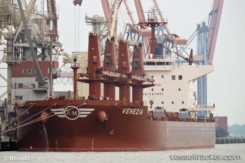
 Venezia
Current Status
Where is the vessel?
Venezia is currently in Near Villa Gobernador Galvez, based on AIS data received about 1h ago.
Latest AIS update:
Current position: 33.04667° S, 60.57167° W (Near Villa Gobernador Galvez)
Average speed (last 7 days): Loading…
Average speed (last 30 days): Loading…
Vessel profile: Venezia is a Bulk Carrier with dimensions 199m x 32m.
This page combines live AIS, route history, probable destination signals, nearby traffic, and port activity for practical vessel monitoring.
The current position of vessel Venezia is -33.04667 lat / -60.57167 lng. Updated: 2026-05-15 14:16:07 UTCNearest reference points:
- Near Quebracho/San Lorenzo
- Near Puerto Alumbrera
- 10 nm NW of San Pedro
Currently sailing under the flag of Malta ![]()
Details:
Live Vessel Venezia Analytics (details, animations, etc.)
Recent AIS points (UTC):
2026-05-15 10:18:43 UTC · -33.04780, -60.57298 · SOG 0 kn · COG 332°2026-05-15 12:00:47 UTC · -33.04775, -60.57296 · SOG 0 kn · COG 332°
2026-05-15 13:54:46 UTC · -33.04778, -60.57294 · SOG 0 kn · COG 332°
2026-05-15 14:16:07 UTC · -33.04667, -60.57167 · SOG 0 kn · COG -1°