 vesseltracker.com
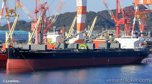
Indigo River
Current StatusWhere is the vessel?
Indigo River is currently in 42 nm NE of Belawan, based on AIS data received less than 1h ago.
Latest AIS update:
Current position: 4.34779° N, 99.07887° E (42 nm NE of Belawan)
Average speed (last 7 days): Loading…
Average speed (last 30 days): Loading…
Vessel profile: Indigo River is a General Cargo Ship with dimensions 32m x 190m.
This page combines live AIS, route history, probable destination signals, nearby traffic, and port activity for practical vessel monitoring.
The current position of vessel Indigo River is 4.34779 lat / 99.07887 lng. Updated: 2026-05-15 23:01:46 UTCNearest reference points:
- 43 nm NE of Perbaungan
- 43 nm NE of PANGKALAN SUSU
- 10 nm NE of Belawan
Details:
Live Vessel Indigo River Analytics (details, animations, etc.)
Recent AIS points (UTC):
2026-05-15 19:48:57 UTC · 4.66437, 98.64790 · SOG 10.4 kn · COG 129°2026-05-15 20:04:57 UTC · 4.63474, 98.68317 · SOG 10.2 kn · COG 131°
2026-05-15 22:04:37 UTC · 4.44555, 98.95849 · SOG 9.9 kn · COG 129°
2026-05-15 23:01:46 UTC · 4.34779, 99.07887 · SOG 9.6 kn · COG 138°