 vesseltracker.com
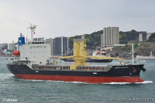
 Ocean Harmony
Current Status
Where is the vessel?
Ocean Harmony is currently in Near KIMITSU, based on AIS data received less than 1h ago.
Latest AIS update:
Current position: 35.41229° N, 139.84259° E (Near KIMITSU)
Average speed (last 7 days): Loading…
Average speed (last 30 days): Loading…
Vessel profile: Ocean Harmony is a General Cargo Ship with dimensions 100m x 19m.
This page combines live AIS, route history, probable destination signals, nearby traffic, and port activity for practical vessel monitoring.
The current position of vessel Ocean Harmony is 35.41229 lat / 139.84259 lng. Updated: 2026-05-14 11:59:32 UTCNearest reference points:
- Near Yokosuka
- Near Kawasaki
- Near Yokohama
Currently sailing under the flag of Panama ![]()
Details:
Live Vessel Ocean Harmony Analytics (details, animations, etc.)
Recent AIS points (UTC):
2026-05-14 07:50:32 UTC · 35.41329, 139.84280 · SOG 0.1 kn · COG 77°2026-05-14 10:26:32 UTC · 35.41238, 139.84251 · SOG 0.1 kn · COG 41°
2026-05-14 11:02:32 UTC · 35.41240, 139.84245 · SOG 0.2 kn · COG 48°
2026-05-14 11:59:32 UTC · 35.41229, 139.84259 · SOG 0.1 kn · COG 46°