 vesseltracker.com
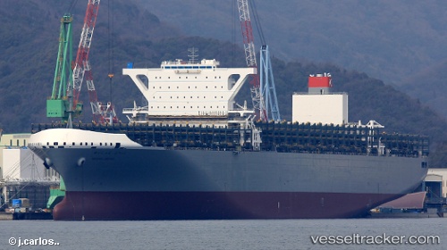
 Meishan Bridge
Current Status
Where is the vessel?
Meishan Bridge is currently in 30 nm S of Knysna, based on AIS data received about 1h ago.
Latest AIS update:
Current position: 34.51807° S, 23.19639° E (30 nm S of Knysna)
Average speed (last 7 days): Loading…
Average speed (last 30 days): Loading…
Vessel profile: Meishan Bridge is a Container Ship with dimensions 365m x 365m.
This page combines live AIS, route history, probable destination signals, nearby traffic, and port activity for practical vessel monitoring.
The current position of vessel Meishan Bridge is -34.51807 lat / 23.19639 lng. Updated: 2026-05-14 13:55:48 UTCNearest reference points:
- Near Mosselbaai
- 16 nm S of Mosselbaai
- 37 nm S of Mosselbaai
Currently sailing under the flag of Japan ![]()
Details:
Live Vessel Meishan Bridge Analytics (details, animations, etc.)
Recent AIS points (UTC):
2026-05-14 10:06:36 UTC · -34.34160, 24.31863 · SOG 14.3 kn · COG 257°2026-05-14 12:17:35 UTC · -34.43387, 23.67948 · SOG 14.8 kn · COG 257°
2026-05-14 13:33:29 UTC · -34.49610, 23.30466 · SOG 15 kn · COG 254°
2026-05-14 13:55:48 UTC · -34.51807, 23.19639 · SOG 15 kn · COG 254°