 vesseltracker.com
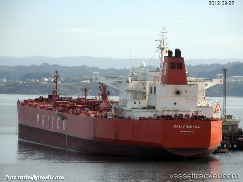
 ZALIV BAIKAL
Current Status
Where is the vessel?
ZALIV BAIKAL is currently in 35 nm SE of WAILINGDING ISLAND, based on AIS data received less than 1h ago.
Latest AIS update:
Current position: 21.55788° N, 114.26627° E (35 nm SE of WAILINGDING ISLAND)
Average speed (last 7 days): Loading…
Average speed (last 30 days): Loading…
Vessel profile: ZALIV BAIKAL is a Crude Oil Tanker with dimensions m x m.
This page combines live AIS, route history, probable destination signals, nearby traffic, and port activity for practical vessel monitoring.
The current position of vessel ZALIV BAIKAL is 21.55788 lat / 114.26627 lng. Updated: 2026-05-02 13:21:36 UTCNearest reference points:
- 33 nm SE of Wanshan Pt
- 42 nm SE of Wanshan Pt
- 15 nm S of WAILINGDING ISLAND
Currently sailing under the flag of Oman ![]()
Details:
Live Vessel ZALIV BAIKAL Analytics (details, animations, etc.)
Recent AIS points (UTC):
2026-05-02 10:12:35 UTC · 21.55677, 114.26697 · SOG 0.1 kn · COG 44°2026-05-02 10:12:35 UTC · 21.55677, 114.26697 · SOG 0.1 kn · COG 44°
2026-05-02 12:17:36 UTC · 21.55740, 114.26654 · SOG 0 kn · COG 67°
2026-05-02 13:21:36 UTC · 21.55788, 114.26627 · SOG 0 kn · COG 83°