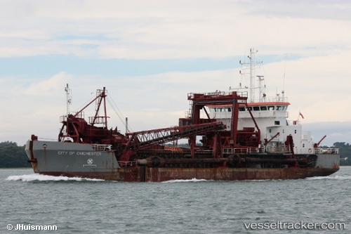
 City Of Chichester
Current Status
Where is the vessel?
City Of Chichester is currently in Near SHOREHAM, based on AIS data received about 14h ago.
Latest AIS update:
Current position: 50.83005° N, 0.22064° W (Near SHOREHAM)
Average speed (last 7 days): Loading…
Average speed (last 30 days): Loading…
Vessel profile: City Of Chichester is a Hopper Dredger with dimensions 72m x 15m.
This page combines live AIS, route history, probable destination signals, nearby traffic, and port activity for practical vessel monitoring.
The current position of vessel City Of Chichester is 50.83005 lat / -0.22064 lng. Updated: 2026-06-28 22:03:50 UTCNearest reference points:
- 23 nm S of Ferring
- 27 nm S of Seaford
- Near CHICHESTER
Currently sailing under the flag of United Kingdom ![]()
City Of Chichester built in 1997 year
Deadweight:
2730 tDetails:
Live Vessel City Of Chichester Analytics (details, animations, etc.)
Recent AIS points (UTC):
2026-06-28 17:38:00 UTC · 50.64388, -0.90917 · SOG 4.2 kn · COG 93°2026-06-28 19:26:08 UTC · 50.74211, -0.38144 · SOG 11.5 kn · COG 59°
2026-06-28 19:46:19 UTC · 50.77365, -0.29499 · SOG 11 kn · COG 60°
2026-06-28 22:03:50 UTC · 50.83005, -0.22064 · SOG 0 kn · COG 283°