 vesseltracker.com
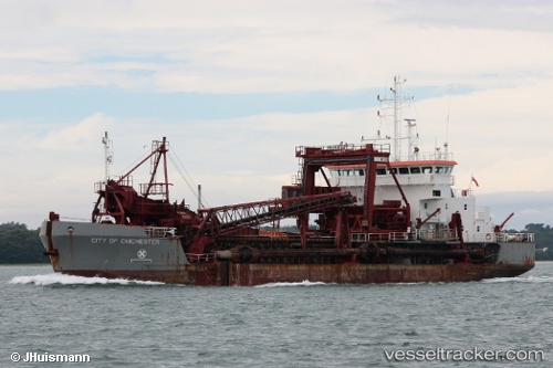
 City Of Chichester
Current Status
Where is the vessel?
City Of Chichester is currently in Near East Cowes, based on AIS data received less than 1h ago.
Latest AIS update:
Current position: 50.75365° N, 1.29239° W (Near East Cowes)
Average speed (last 7 days): Loading…
Average speed (last 30 days): Loading…
Vessel profile: City Of Chichester is a Hopper Dredger with dimensions 72m x 15m.
This page combines live AIS, route history, probable destination signals, nearby traffic, and port activity for practical vessel monitoring.
The current position of vessel City Of Chichester is 50.75365 lat / -1.29239 lng. Updated: 2026-05-13 06:13:02 UTCNearest reference points:
- Near East Cowes
- Near FAWLEY
- Near HAMBLE POINT
Currently sailing under the flag of United Kingdom ![]()
City Of Chichester built in 1997 year
Deadweight:
2730 tDetails:
Live Vessel City Of Chichester Analytics (details, animations, etc.)
Recent AIS points (UTC):
2026-05-13 02:24:14 UTC · 50.73165, -0.98618 · SOG 0 kn · COG 251°2026-05-13 03:33:15 UTC · 50.73164, -0.98617 · SOG 0 kn · COG 256°
2026-05-13 04:03:18 UTC · 50.73157, -0.98617 · SOG 0 kn · COG 258°
2026-05-13 06:13:02 UTC · 50.75365, -1.29239 · SOG 4 kn · COG 183°