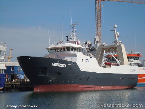
 Cap Saint Georges
Current Status
Where is the vessel?
Cap Saint Georges is currently in 33 nm NW of Unst, based on AIS data received about 15h ago.
Latest AIS update:
Current position: 61.23047° N, 1.46586° W (33 nm NW of Unst)
Average speed (last 7 days): Loading…
Average speed (last 30 days): Loading…
Vessel profile: Cap Saint Georges is a Fishing Vessel with dimensions 44m x 10m.
This page combines live AIS, route history, probable destination signals, nearby traffic, and port activity for practical vessel monitoring.
The current position of vessel Cap Saint Georges is 61.23047 lat / -1.46586 lng. Updated: 2026-05-23 01:40:02 UTCNearest reference points:
- 32 nm NW of Eshaness
- 36 nm NW of Ham Voe, Foula
- Near Tingwall
Currently sailing under the flag of France ![]()
Details:
Live Vessel Cap Saint Georges Analytics (details, animations, etc.)
Recent AIS points (UTC):
2026-05-22 22:27:52 UTC · 61.06333, -1.79167 · SOG 4 kn · COG -1°2026-05-22 23:45:51 UTC · 61.12333, -1.64167 · SOG 4 kn · COG -1°
2026-05-23 01:34:13 UTC · 61.22637, -1.47766 · SOG 4.3 kn · COG 45°
2026-05-23 01:40:02 UTC · 61.23047, -1.46586 · SOG 4.2 kn · COG 58°