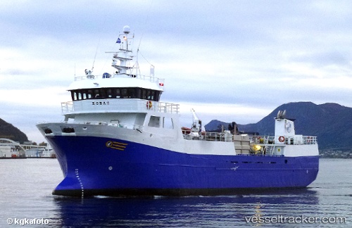
Robas
Current StatusWhere is the vessel?
Robas is currently in Near VARALDSOY, based on AIS data received about 15h ago.
Latest AIS update:
Current position: 60.12707° N, 5.93124° E (Near VARALDSOY)
Average speed (last 7 days): Loading…
Average speed (last 30 days): Loading…
Vessel profile: Robas is a Fish Carrier with dimensions 10m x 46m.
This page combines live AIS, route history, probable destination signals, nearby traffic, and port activity for practical vessel monitoring.
The current position of vessel Robas is 60.12707 lat / 5.93124 lng. Updated: 2026-05-18 21:43:10 UTCNearest reference points:
- Near ROSENDAL
- Near OMASTRANDA
- Near Halsnøy
Details:
Live Vessel Robas Analytics (details, animations, etc.)
Recent AIS points (UTC):
2026-05-18 17:33:29 UTC · 59.94325, 5.15705 · SOG 10.2 kn · COG 68°2026-05-18 19:12:33 UTC · 59.87728, 5.59546 · SOG 10.9 kn · COG 134°
2026-05-18 20:21:51 UTC · 59.98781, 5.87128 · SOG 10.4 kn · COG 45°
2026-05-18 21:43:10 UTC · 60.12707, 5.93124 · SOG 0 kn · COG 39°