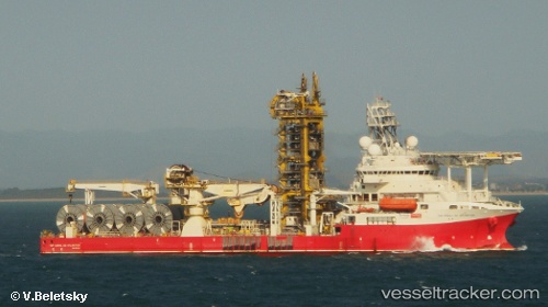
 CORAL DO ATLANTICO
Current Status
Where is the vessel?
CORAL DO ATLANTICO is currently in 17 nm NW of Torreira, based on AIS data received about 14h ago.
Latest AIS update:
Current position: 40.88036° N, 9.03469° W (17 nm NW of Torreira)
Average speed (last 7 days): Loading…
Average speed (last 30 days): Loading…
Vessel profile: CORAL DO ATLANTICO is a Not available with dimensions m x m.
This page combines live AIS, route history, probable destination signals, nearby traffic, and port activity for practical vessel monitoring.
The current position of vessel CORAL DO ATLANTICO is 40.88036 lat / -9.03469 lng. Updated: 2026-05-19 19:51:28 UTCNearest reference points:
- Near Gafanha da Nazaré
- Near Matosinhos
- Near POVOA DE VARZIM
Currently sailing under the flag of Bahamas ![]()
Details:
Live Vessel CORAL DO ATLANTICO Analytics (details, animations, etc.)
Recent AIS points (UTC):
2026-05-19 17:08:35 UTC · 41.19263, -8.68816 · SOG 0.2 kn · COG -1°2026-05-19 18:08:08 UTC · 41.10903, -8.77007 · SOG 10.2 kn · COG 218°
2026-05-19 19:50:19 UTC · 40.88307, -9.03173 · SOG 10.9 kn · COG 221°
2026-05-19 19:51:28 UTC · 40.88036, -9.03469 · SOG 10.7 kn · COG 221°