 vesseltracker.com
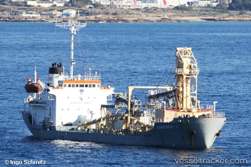
 EVIACEMENT III
Current Status
Where is the vessel?
EVIACEMENT III is currently in Near AL ARISH, based on AIS data received about 14h ago.
Latest AIS update:
Current position: 31.15408° N, 33.83574° E (Near AL ARISH)
Average speed (last 7 days): Loading…
Average speed (last 30 days): Loading…
Vessel profile: EVIACEMENT III is a Cement Carrier with dimensions m x m.
This page combines live AIS, route history, probable destination signals, nearby traffic, and port activity for practical vessel monitoring.
The current position of vessel EVIACEMENT III is 31.15408 lat / 33.83574 lng. Updated: 2026-05-17 23:05:31 UTCNearest reference points:
- Near AL ARISH
- 17 nm E of Atakka Dry Port
- 24 nm SW of Atakka Dry Port
Currently sailing under the flag of Panama ![]()
Details:
Live Vessel EVIACEMENT III Analytics (details, animations, etc.)
Recent AIS points (UTC):
2026-05-17 19:03:28 UTC · 31.15333, 33.83500 · SOG 0 kn · COG -1°2026-05-17 19:30:35 UTC · 31.15333, 33.83500 · SOG 0 kn · COG -1°
2026-05-17 21:51:29 UTC · 31.15333, 33.83500 · SOG 0 kn · COG -1°
2026-05-17 23:05:31 UTC · 31.15408, 33.83574 · SOG 0 kn · COG 256°