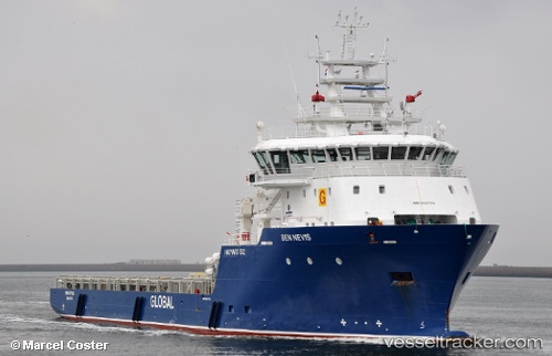
 BEN NEVIS
Current Status
Where is the vessel?
BEN NEVIS is currently in Near Muara, based on AIS data received about 15h ago.
Latest AIS update:
Current position: 5.12500° N, 115.11500° E (Near Muara)
Average speed (last 7 days): Loading…
Average speed (last 30 days): Loading…
Vessel profile: BEN NEVIS is a Offshore Supply Ship with dimensions m x m.
This page combines live AIS, route history, probable destination signals, nearby traffic, and port activity for practical vessel monitoring.
The current position of vessel BEN NEVIS is 5.12500 lat / 115.11500 lng. Updated: 2026-05-21 13:49:03 UTCNearest reference points:
- Near Kikeh
- 44 nm SW of Tembungo
- 11 nm N of MIRI
Currently sailing under the flag of Panama ![]()
Details:
Live Vessel BEN NEVIS Analytics (details, animations, etc.)
Recent AIS points (UTC):
2026-05-21 09:52:01 UTC · 5.30667, 114.72500 · SOG 7 kn · COG -1°2026-05-21 12:14:23 UTC · 5.16305, 114.95507 · SOG 7 kn · COG 124°
2026-05-21 13:33:32 UTC · 5.12325, 115.08843 · SOG 6.1 kn · COG 93°
2026-05-21 13:49:03 UTC · 5.12500, 115.11500 · SOG 6 kn · COG -1°