Ingrid
Current StatusWhere is the vessel?
Ingrid is currently in 20 nm SE of Port Royal, based on AIS data received about 14h ago.
Latest AIS update:
Current position: 32.22159° N, 76.83191° W (20 nm SE of Port Royal)
Average speed (last 7 days): Loading…
Average speed (last 30 days): Loading…
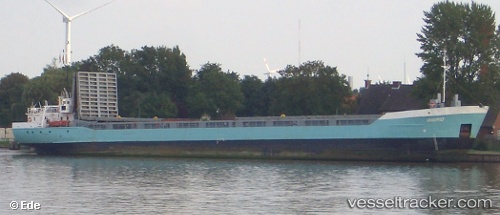
Vessel profile: Ingrid is a Offshore Tug Supply Ship with dimensions 8m x 80m.
This page combines live AIS, route history, probable destination signals, nearby traffic, and port activity for practical vessel monitoring.
The current position of vessel Ingrid is 32.22159 lat / -76.83191 lng. Updated: 2026-05-19 22:02:50 UTCNearest reference points:
- Near Morehead City
- Near North Myrtle Beach
- Near BEAUFORT
Details:
Live Vessel Ingrid Analytics (details, animations, etc.)
Recent AIS points (UTC):
2026-05-19 17:45:57 UTC · 32.08880, -77.33651 · SOG 6.3 kn · COG 81°2026-05-19 19:54:39 UTC · 32.16333, -77.08333 · SOG 2 kn · COG -1°
2026-05-19 20:24:38 UTC · 32.17333, -77.03167 · SOG 6 kn · COG -1°
2026-05-19 22:02:50 UTC · 32.22159, -76.83191 · SOG 6.7 kn · COG 86°