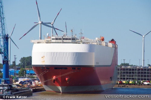
 Orion Highway
Current Status
Where is the vessel?
Orion Highway is currently in 318 nm W of Tinaquillo, based on AIS data received about 15h ago.
Latest AIS update:
Current position: 8.30311° N, 63.18305° E (318 nm W of Tinaquillo)
Average speed (last 7 days): Loading…
Average speed (last 30 days): Loading…
Vessel profile: Orion Highway is a Vehicles Carrier with dimensions 199m x 37m.
This page combines live AIS, route history, probable destination signals, nearby traffic, and port activity for practical vessel monitoring.
The current position of vessel Orion Highway is 8.30311 lat / 63.18305 lng. Updated: 2026-05-23 04:11:11 UTCNearest reference points:
- Open sea, approx. 400 nm off the nearest listed port
- Open sea, approx. 402 nm off the nearest listed port
- Open sea, approx. 404 nm off the nearest listed port
Currently sailing under the flag of Panama ![]()
Details:
Live Vessel Orion Highway Analytics (details, animations, etc.)
Recent AIS points (UTC):
2026-05-23 00:39:44 UTC · 7.57043, 62.51205 · SOG 17 kn · COG 40°2026-05-23 01:56:59 UTC · 7.84131, 62.76158 · SOG 17 kn · COG 41°
2026-05-23 01:56:59 UTC · 7.84131, 62.76158 · SOG 17 kn · COG 41°
2026-05-23 04:11:11 UTC · 8.30311, 63.18305 · SOG 16.3 kn · COG 40°