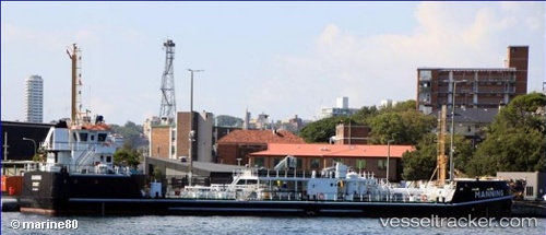
Manning
Current StatusWhere is the vessel?
Manning is currently in Near Woolloomooloo, based on AIS data received about 14h ago.
Latest AIS update:
Current position: 33.86832° S, 151.22209° E (Near Woolloomooloo)
Average speed (last 7 days): Loading…
Average speed (last 30 days): Loading…
Vessel profile: Manning is a Oil Products Tanker with dimensions 12m x 63m.
This page combines live AIS, route history, probable destination signals, nearby traffic, and port activity for practical vessel monitoring.
The current position of vessel Manning is -33.86832 lat / 151.22209 lng. Updated: 2026-05-22 17:03:37 UTCNearest reference points:
- Near Woolloomooloo
- Near Darling Point
- Near Cremorne
Details:
Live Vessel Manning Analytics (details, animations, etc.)
Recent AIS points (UTC):
2026-05-22 13:51:23 UTC · -33.86837, 151.22208 · SOG 0 kn · COG 206°2026-05-22 14:03:23 UTC · -33.86848, 151.22202 · SOG 0 kn · COG 207°
2026-05-22 15:39:20 UTC · -33.86826, 151.22202 · SOG 0 kn · COG 207°
2026-05-22 17:03:37 UTC · -33.86832, 151.22209 · SOG 0 kn · COG 207°