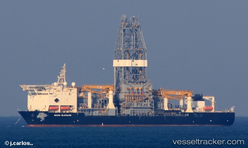
Ocean Blacklion
Current StatusWhere is the vessel?
Ocean Blacklion is currently in 45 nm SE of Gulfmex Lightering Area, based on AIS data received about 18h ago.
Latest AIS update:
Current position: 27.14667° N, 90.31833° W (45 nm SE of Gulfmex Lightering Area)
Average speed (last 7 days): Loading…
Average speed (last 30 days): Loading…
Vessel profile: Ocean Blacklion is a Drilling Ship with dimensions 36m x 230m.
This page combines live AIS, route history, probable destination signals, nearby traffic, and port activity for practical vessel monitoring.
The current position of vessel Ocean Blacklion is 27.14667 lat / -90.31833 lng. Updated: 2026-05-21 14:50:19 UTCNearest reference points:
- 94 nm S of Gulfmex Lightering Area
- Near Port Fourchon
- Near FOURCHON
Details:
Live Vessel Ocean Blacklion Analytics (details, animations, etc.)
Recent AIS points (UTC):
2026-05-21 14:50:19 UTC · 27.14667, -90.31833 · SOG 0 kn · COG -1°2026-05-21 14:50:19 UTC · 27.14667, -90.31833 · SOG 0 kn · COG -1°
2026-05-21 14:50:19 UTC · 27.14667, -90.31833 · SOG 0 kn · COG -1°
2026-05-21 14:50:19 UTC · 27.14667, -90.31833 · SOG 0 kn · COG -1°