 Stolt Strength
Current Status
Where is the vessel?
Stolt Strength is currently in 42 nm SE of HATTERAS, based on AIS data received about 14h ago.
Latest AIS update:
Current position: 34.63725° N, 75.21941° W (42 nm SE of HATTERAS)
Average speed (last 7 days): Loading…
Average speed (last 30 days): Loading…
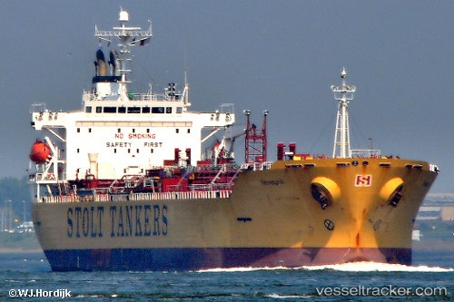
Vessel profile: Stolt Strength is a Chemical Oil Products Tanker with dimensions 174m x 28m.
This page combines live AIS, route history, probable destination signals, nearby traffic, and port activity for practical vessel monitoring.
The current position of vessel Stolt Strength is 34.63725 lat / -75.21941 lng. Updated: 2026-05-23 06:27:46 UTCNearest reference points:
- Near HATTERAS
- 18 nm NE of Rodanthe
- Near Nags Head
Currently sailing under the flag of Liberia ![]()
Details:
Live Vessel Stolt Strength Analytics (details, animations, etc.)
Recent AIS points (UTC):
2026-05-23 02:47:59 UTC · 35.05500, -74.55167 · SOG 11 kn · COG -1°2026-05-23 03:24:00 UTC · 34.98167, -74.66500 · SOG 11 kn · COG -1°
2026-05-23 04:15:00 UTC · 34.88333, -74.82167 · SOG 11 kn · COG -1°
2026-05-23 06:27:46 UTC · 34.63725, -75.21941 · SOG 11.4 kn · COG 228°