 Sunda
Sunda
Current Status
Where is the vessel?
Sunda is currently in 13 nm N of Metis-sur-Mer, based on AIS data received about 16h ago.
Latest AIS update:
Current position: 48.87667° N, 67.98500° W (13 nm N of Metis-sur-Mer)
Average speed (last 7 days): Loading…
Average speed (last 30 days): Loading…
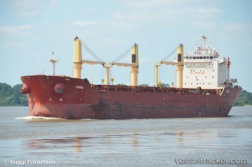
Vessel profile: Sunda is a Bulk Carrier with dimensions 186m x 24m.
This page combines live AIS, route history, probable destination signals, nearby traffic, and port activity for practical vessel monitoring.
The current position of vessel Sunda is 48.87667 lat / -67.98500 lng. Updated: 2026-05-23 07:35:59 UTCNearest reference points:
- 15 nm NW of Saint-Anaclet
- 22 nm N of Sainte-Anne-des-Monts
- Near Ile Aux Coudres
Currently sailing under the flag of Liberia ![]()
Sunda built in 2010 year
Deadweight:
29800 tDetails:
Live Vessel Sunda Analytics (details, animations, etc.)
Recent AIS points (UTC):
2026-05-23 04:56:08 UTC · 48.58326, -68.67660 · SOG 13.8 kn · COG 56°2026-05-23 06:22:09 UTC · 48.74533, -68.30315 · SOG 11.7 kn · COG 59°
2026-05-23 07:03:29 UTC · 48.81893, -68.12816 · SOG 11.9 kn · COG 58°
2026-05-23 07:35:59 UTC · 48.87667, -67.98500 · SOG 12 kn · COG -1°