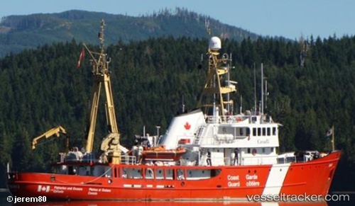
Tanu
Current StatusWhere is the vessel?
Tanu is currently in 45 nm NW of PORT HARDY, based on AIS data received about 14h ago.
Latest AIS update:
Current position: 51.35035° N, 128.10571° W (45 nm NW of PORT HARDY)
Average speed (last 7 days): Loading…
Average speed (last 30 days): Loading…
Vessel profile: Tanu is a Fishing Support Vessel with dimensions 10m x 55m.
This page combines live AIS, route history, probable destination signals, nearby traffic, and port activity for practical vessel monitoring.
The current position of vessel Tanu is 51.35035 lat / -128.10571 lng. Updated: 2026-05-19 04:41:20 UTCNearest reference points:
- 63 nm N of PORT HARDY
- 29 nm NW of Coal Harbour
- Near PORT HARDY
Details:
Live Vessel Tanu Analytics (details, animations, etc.)
Recent AIS points (UTC):
2026-05-19 01:57:01 UTC · 51.65156, -127.96762 · SOG 8.2 kn · COG 92°2026-05-19 02:32:31 UTC · 51.58757, -127.87898 · SOG 10.3 kn · COG 168°
2026-05-19 03:26:51 UTC · 51.43758, -127.83720 · SOG 10.8 kn · COG 203°
2026-05-19 04:41:20 UTC · 51.35035, -128.10571 · SOG 10.2 kn · COG 279°