 vesseltracker.com
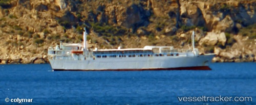
 Freedom
Current Status
Where is the vessel?
Freedom is currently in 22 nm SW of Kythira, based on AIS data received less than 1h ago.
Latest AIS update:
Current position: 35.91703° N, 22.62473° E (22 nm SW of Kythira)
Average speed (last 7 days): Loading…
Average speed (last 30 days): Loading…
Vessel profile: Freedom is a Livestock Carrier with dimensions 87m x 16m.
This page combines live AIS, route history, probable destination signals, nearby traffic, and port activity for practical vessel monitoring.
The current position of vessel Freedom is 35.91703 lat / 22.62473 lng. Updated: 2026-05-18 02:17:48 UTCNearest reference points:
- Near Kythira
- 17 nm S of Areópolis
- 59 nm W of Paleochora
Currently sailing under the flag of Lebanon ![]()
Freedom built in 1971 year
Deadweight:
2794 tDetails:
Live Vessel Freedom Analytics (details, animations, etc.)
Recent AIS points (UTC):
2026-05-17 23:06:07 UTC · 36.05189, 23.13564 · SOG 8.8 kn · COG 256°2026-05-17 23:40:38 UTC · 36.03975, 23.04097 · SOG 7.1 kn · COG 268°
2026-05-18 02:17:48 UTC · 35.91703, 22.62473 · SOG 9.2 kn · COG 254°
2026-05-18 02:17:48 UTC · 35.91703, 22.62473 · SOG 9.2 kn · COG 254°