 vesseltracker.com
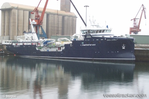
 RONIA POLARIS
Current Status
Where is the vessel?
RONIA POLARIS is currently in Near Puerto Montt, based on AIS data received about 14h ago.
Latest AIS update:
Current position: 41.51784° S, 73.01369° W (Near Puerto Montt)
Average speed (last 7 days): Loading…
Average speed (last 30 days): Loading…
Vessel profile: RONIA POLARIS is a Fish Carrier with dimensions m x m.
This page combines live AIS, route history, probable destination signals, nearby traffic, and port activity for practical vessel monitoring.
The current position of vessel RONIA POLARIS is -41.51784 lat / -73.01369 lng. Updated: 2026-05-18 13:48:16 UTCNearest reference points:
- Near Puerto Montt
- Near Chonchi
- Near Quellón (Puerto Quellón)
Details:
Live Vessel RONIA POLARIS Analytics (details, animations, etc.)
Recent AIS points (UTC):
2026-05-18 11:06:15 UTC · -41.51760, -73.01365 · SOG 0 kn · COG 99°2026-05-18 12:03:14 UTC · -41.51758, -73.01355 · SOG 0 kn · COG 107°
2026-05-18 13:21:35 UTC · -41.51782, -73.01381 · SOG 0 kn · COG 80°
2026-05-18 13:48:16 UTC · -41.51784, -73.01369 · SOG 0 kn · COG 93°