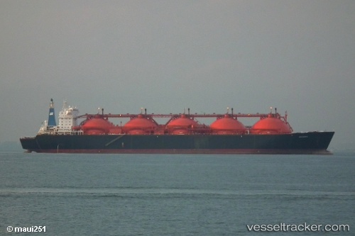
Gandria
Current StatusWhere is the vessel?
Gandria is currently in Near NHAVA SHEVA, based on AIS data received about 15d ago.
Latest AIS update:
Current position: 18.95366° N, 72.94540° E (Near NHAVA SHEVA)
Average speed (last 7 days): Loading…
Average speed (last 30 days): Loading…
Vessel profile: Gandria is a Lng Tanker with dimensions 42m x 288m.
This page combines live AIS, route history, probable destination signals, nearby traffic, and port activity for practical vessel monitoring.
The current position of vessel Gandria is 18.95366 lat / 72.94540 lng. Updated: 2026-05-03 18:07:06 UTCNearest reference points:
- Near NHAVA SHEVA
- Near Mumbai
- Near HNB SEZ/Mumbai
Details:
Live Vessel Gandria Analytics (details, animations, etc.)
Recent AIS points (UTC):
2026-05-03 18:07:06 UTC · 18.95366, 72.94540 · SOG 0 kn · COG 25°2026-05-03 18:07:06 UTC · 18.95366, 72.94540 · SOG 0 kn · COG 25°
2026-05-03 18:07:06 UTC · 18.95366, 72.94540 · SOG 0 kn · COG 25°
2026-05-03 18:07:06 UTC · 18.95366, 72.94540 · SOG 0 kn · COG 25°