 vesseltracker.com
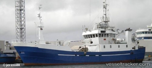
 COSTA DE AGUINO
Current Status
Where is the vessel?
COSTA DE AGUINO is currently in Open sea, approx. 429 nm off the nearest listed port, based on AIS data received about 14h ago.
Latest AIS update:
Current position: 8.67699° N, 28.11332° W (Open sea, approx. 429 nm off the nearest listed port)
Average speed (last 7 days): Loading…
Average speed (last 30 days): Loading…
Vessel profile: COSTA DE AGUINO is a Fishing Vessel with dimensions m x m.
This page combines live AIS, route history, probable destination signals, nearby traffic, and port activity for practical vessel monitoring.
The current position of vessel COSTA DE AGUINO is 8.67699 lat / -28.11332 lng. Updated: 2026-05-18 05:21:58 UTCNearest reference points:
- Open sea, approx. 429 nm off the nearest listed port
- Open sea, approx. 430 nm off the nearest listed port
- Open sea, approx. 428 nm off the nearest listed port
Currently sailing under the flag of Cabo Verde ![]()
Details:
Live Vessel COSTA DE AGUINO Analytics (details, animations, etc.)
Recent AIS points (UTC):
2026-05-18 02:02:56 UTC · 8.63566, -28.13014 · SOG 0.2 kn · COG -1°2026-05-18 03:40:18 UTC · 8.61817, -28.14276 · SOG 0.2 kn · COG -1°
2026-05-18 05:03:38 UTC · 8.67329, -28.11673 · SOG 2.5 kn · COG -1°
2026-05-18 05:21:58 UTC · 8.67699, -28.11332 · SOG 1.8 kn · COG -1°