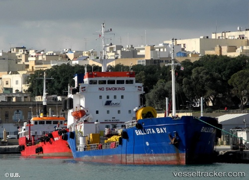
 Balluta Bay
Current Status
Where is the vessel?
Balluta Bay is currently in 13 nm E of Il-Kappara, based on AIS data received about 15h ago.
Latest AIS update:
Current position: 35.87964° N, 14.84112° E (13 nm E of Il-Kappara)
Average speed (last 7 days): Loading…
Average speed (last 30 days): Loading…
Vessel profile: Balluta Bay is a Oil Products Tanker with dimensions 79m x 13m.
This page combines live AIS, route history, probable destination signals, nearby traffic, and port activity for practical vessel monitoring.
The current position of vessel Balluta Bay is 35.87964 lat / 14.84112 lng. Updated: 2026-05-20 17:15:11 UTCNearest reference points:
- 13 nm E of Il-Kappara
- 18 nm E of Il-Kappara
- Near Xghajra
Currently sailing under the flag of Malta ![]()
Balluta Bay built in 1981 year
Deadweight:
3027 tDetails:
Live Vessel Balluta Bay Analytics (details, animations, etc.)
Recent AIS points (UTC):
2026-05-20 13:48:00 UTC · 35.81456, 14.54470 · SOG 0 kn · COG 225°2026-05-20 16:22:13 UTC · 35.86915, 14.82884 · SOG 6.5 kn · COG 55°
2026-05-20 16:26:55 UTC · 35.87368, 14.83614 · SOG 5.4 kn · COG 46°
2026-05-20 17:15:11 UTC · 35.87964, 14.84112 · SOG 0.1 kn · COG 16°