 TOPAZ COAST
Current Status
Where is the vessel?
TOPAZ COAST is currently in Near South Baltimore, based on AIS data received about 14h ago.
Latest AIS update:
Current position: 39.27637° N, 76.59313° W (Near South Baltimore)
Average speed (last 7 days): Loading…
Average speed (last 30 days): Loading…
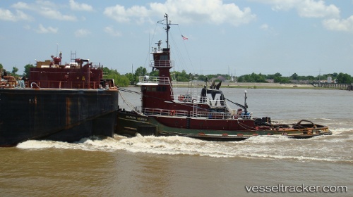
Vessel profile: TOPAZ COAST is a Tug with dimensions 38m x 10m.
This page combines live AIS, route history, probable destination signals, nearby traffic, and port activity for practical vessel monitoring.
The current position of vessel TOPAZ COAST is 39.27637 lat / -76.59313 lng. Updated: 2026-05-22 07:24:26 UTCNearest reference points:
- Near Baltimore
- Near South Baltimore
- Near DUNDALK
Currently sailing under the flag of United States of America ![]()
TOPAZ COAST built in 1982 year
Deadweight:
10 tDetails:
Live Vessel TOPAZ COAST Analytics (details, animations, etc.)
Recent AIS points (UTC):
2026-05-22 03:50:57 UTC · 39.27635, -76.59307 · SOG 0 kn · COG 247°2026-05-22 04:40:47 UTC · 39.27638, -76.59308 · SOG 0 kn · COG 245°
2026-05-22 06:18:56 UTC · 39.27634, -76.59313 · SOG 0 kn · COG 245°
2026-05-22 07:24:26 UTC · 39.27637, -76.59313 · SOG 0 kn · COG 246°